The Boundary on the Map Is Not the Whole Neighbourhood
A neighbourhood boundary can clarify local services, but tracing daily routes and shared places reveals the connections a map leaves outside.
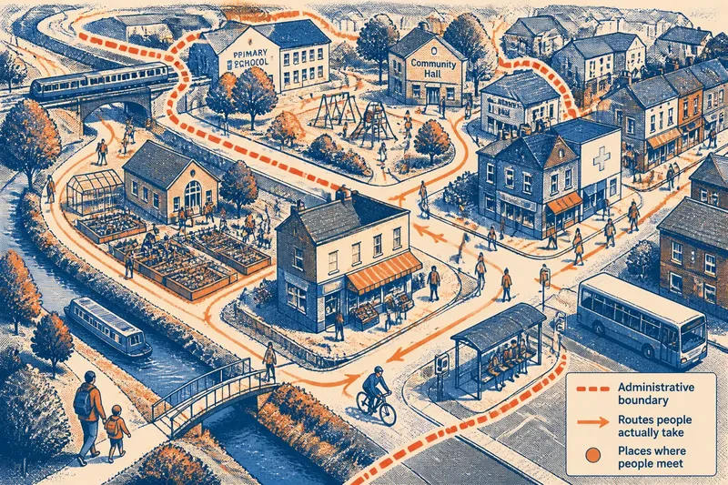
A neighbourhood boundary can tell you which council area or service team covers an address, but it cannot describe the whole neighbourhood people use. The boundary on the map is a useful administrative line; the lived neighbourhood also takes shape through routes, shared places and everyday connections that may cross it.
That distinction matters when reading local information or talking about a place’s needs. Treating a boundary as a complete account can make nearby streets, facilities and relationships disappear from the picture. These six ways of looking beyond the line help build a fuller, more grounded understanding.
1. Separate service areas from lived places
An administrative boundary answers a specific question: which authority, ward, service team or funding area is responsible here? A lived neighbourhood answers something different: where do people go, meet and feel that they belong? The two areas can overlap without matching.
A school may serve families from several council wards, while a council service may be organised around a boundary residents rarely mention. Neither arrangement is inherently confusing; difficulty begins when a service map is mistaken for a map of social life. Check what the map was designed to show before using it to describe a community.
When a council website labels an area, look for the map legend and the name of the boundary type. A ward map, a housing management area and a neighbourhood policing area can each draw different lines through the same streets. Naming the purpose of the line makes comparisons more precise.
2. Follow the routes people actually take
Daily movement often links places that a boundary separates. Residents may walk along a high street, cross a railway bridge to reach a bus stop or use a path through a neighbouring estate to get to a park. Those routes connect parts of local life even if they cross into another administrative area.
Imagine a family living near the edge of one ward whose nearest library, GP practice and grocery shops sit across the line. If they use the same crossing and shopping street week after week, those places are likely part of their practical neighbourhood. A route map marked with these regular destinations would show the expected connections more clearly than the ward outline alone.
Routes also reveal barriers. A busy road, a steep slope or an inaccessible crossing can make two nearby streets feel far apart, while a direct footpath can connect places that appear separate on a road map. A map shows distance and layout; residents’ accounts help explain whether the route is usable.
3. Notice the places where different groups meet
Neighbourhood ties can gather around everyday places rather than a named district. A corner shop, playground, community garden, faith venue or bus shelter may be where residents exchange local news or see familiar faces. These meeting points are easy to miss if an account focuses only on official borders or prominent buildings.
Consider which places serve different ages and routines. A playground may connect carers during the afternoon, while a shared hall hosts a residents’ group in the evening. The same area can contain several overlapping networks, and no single venue should be assumed to represent everyone who lives nearby.
When describing a place, name the meeting point and the people or activities associated with it, rather than claiming it speaks for the whole neighbourhood. That wording leaves room for residents whose routines, access needs or social ties lead elsewhere.
4. Ask whose version of the neighbourhood is visible
Maps and local descriptions often reflect the information an organisation can collect: addresses, service catchments, property records or ward membership. That can be useful, but it may give less space to informal connections, temporary residents, people who work locally or residents who find official consultation difficult to access.
A neighbourhood account can become skewed if it relies on one venue, one group or one set of regular attendees. Ask who is missing from the picture and whether language, mobility, caring responsibilities or meeting times might affect who contributes. This is not a reason to dismiss an official map; it is a prompt to distinguish its evidence from the wider range of local experience.
Keep descriptions specific. “Residents using the market street” identifies a connection that can be discussed, while “the neighbourhood wants” may imply a shared view that has not been established. Careful wording makes it easier to see where experiences overlap and where they differ.
5. Use boundary-crossing connections to explain local needs
A service issue may be experienced in one place and handled by another organisation or area. A poorly lit path, for example, might connect homes in one ward with a bus stop managed under a different arrangement. Describing only the ward where the path begins can obscure the full journey and the points where responsibility changes.
When raising a local concern, describe the route or location in plain terms, identify the relevant map or service area if known, and note how people use the place. If responsibility is unclear, ask the relevant council or service team to identify which body handles the issue. The aim is not to assume that one organisation is responsible for everything along a route, but to make the connection visible enough to investigate.
This approach is also useful when comparing local information. A park’s boundary, its users’ travel routes and the council ward that contains its entrance may all describe different aspects of the same place. Keeping those layers distinct prevents a simple line from being asked to answer a more complicated question.
6. Describe the neighbourhood in layers
A clear description can combine the formal area with the connections people recognise. Start with the administrative label when it matters, then add the nearby streets, routes or shared places that shape daily use. This gives readers a location they can check and a sense of how the area works in practice.
For example, instead of treating “North Ward” as a complete description, a local note might say that the issue concerns homes near the canal path, used to reach the market street and the bus interchange just beyond the ward line. The administrative location remains clear, while the relevant movement and destinations are also named.
Use this layered description when reading a local map or explaining a neighbourhood concern:
- Identify the line: Is it a ward, service area, property boundary or another formal division?
- Name the route: Which streets, paths or crossings connect the place to everyday destinations?
- Locate shared places: Which shops, parks, halls or stops bring people into contact?
- Note who may be missing: Does the account reflect only one group or routine?
- Keep responsibilities distinct: Which organisation’s boundary is relevant to the specific service or issue?
The boundary on the map still matters: it can identify representation, service responsibility or a formal area for local decisions. But it is one layer, not the full neighbourhood. Pairing it with routes and shared places gives residents a more useful way to describe where local life connects—and where a line on a map stops telling the story.